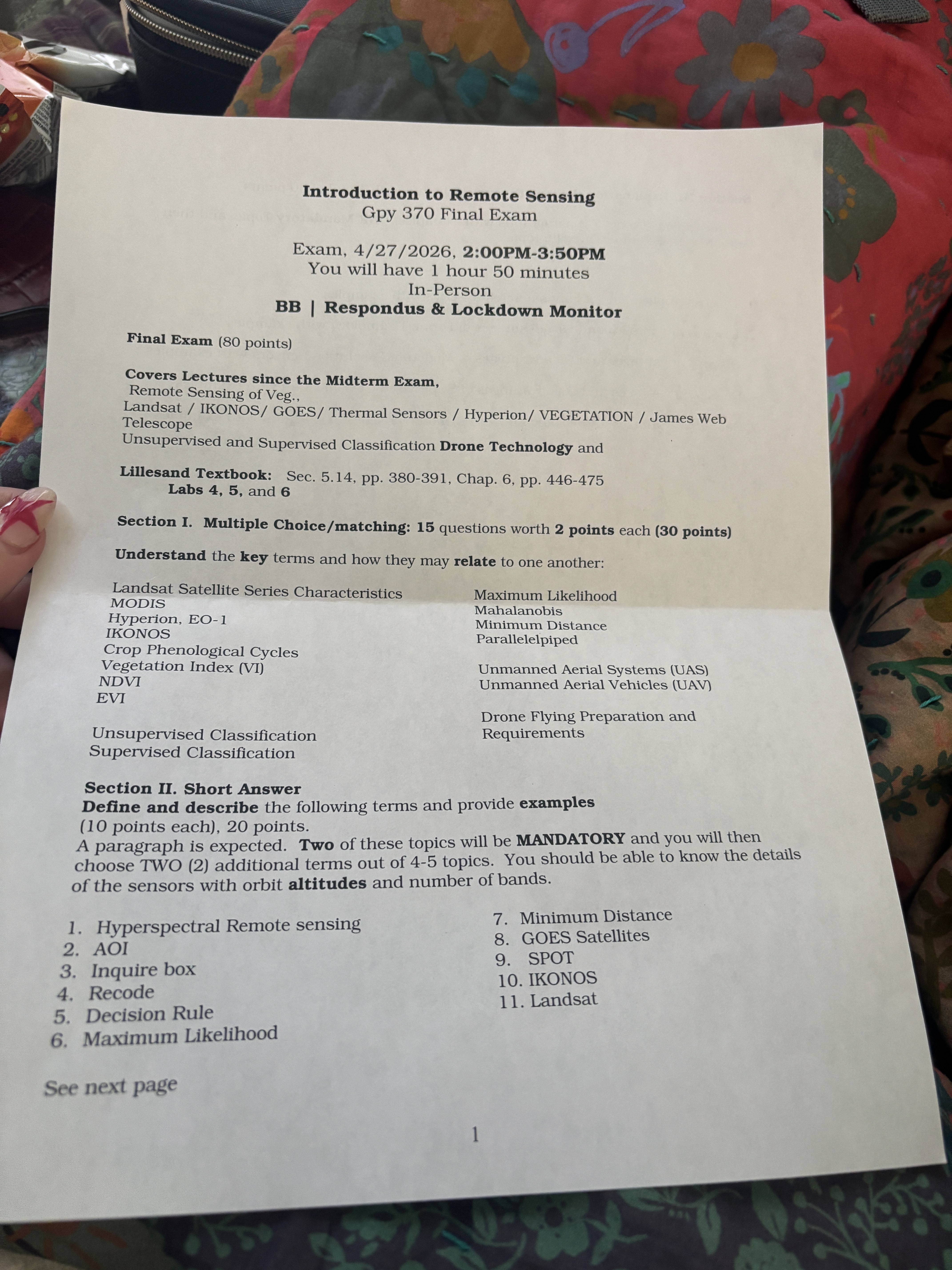
Scope
Everything since the midterm:
- Remote Sensing of Vegetation
- Landsat, IKONOS, GOES, Thermal Sensors, Hyperion, VEGETATION, James Webb Telescope
- Unsupervised and Supervised Classification
- Drone Technology
Readings: Lillesand textbook §5.14 (pp. 380–391), Chapter 6 (pp. 446–475). Labs 4, 5, and 6.
Section I — Multiple Choice / Matching
15 questions × 2 points = 30 points. Know the key terms and how they relate to one another.
Sensors & indices
- Landsat Satellite Series Characteristics
- MODIS
- Hyperion, EO-1
- IKONOS
- Crop Phenological Cycles
- Vegetation Index (VI)
- NDVI
- EVI
Classification & drones
- Unsupervised Classification
- Supervised Classification
- Maximum Likelihood
- Mahalanobis
- Minimum Distance
- Parallelepiped
- Unmanned Aerial Systems (UAS)
- Unmanned Aerial Vehicles (UAV)
- Drone Flying Preparation and Requirements
Section II — Short Answer
2 × 10 points = 20 points. A paragraph is expected for each term: a definition, description, and an example.
Structure: Two of the topics will be mandatory; you then choose two (2) more from a set of 4–5.
Know sensor detail — orbit altitude and number of bands, for each sensor asked about.
1. Hyperspectral Remote Sensing
Hyperspectral remote sensing collects data in hundreds of narrow, contiguous spectral bands (typically 5–10 nm wide) rather than a handful of broad ones. This produces a full reflectance spectrum for every pixel, which can be matched against lab spectra to identify specific minerals, vegetation species, and pollutants.
- Example sensor: Hyperion on EO-1 — 220 bands, 0.4–2.5 µm, 30 m pixels, 705 km orbit.
- Trade-off: massive data volume and low SNR per band; redundancy usually reduced via PCA or minimum-noise-fraction (MNF) before classification.
2. AOI (Area of Interest)
AOI (Area of Interest) is a user-defined spatial subset — a polygon, rectangle, or irregular shape — that restricts an operation to a portion of an image. In ERDAS Imagine, an AOI can be a single region or a layer of regions and is used to clip, classify, or statistically summarize just that area.
- Why: saves processing time and disk space, and keeps training statistics focused on the intended target (e.g., only the agricultural valley, not the whole scene).
3. Inquire box
The Inquire Box is a resizable rectangle drawn on an image in ERDAS Imagine used to subset the scene — either interactively exploring pixel values or feeding Subset & Chip → From Inquire Box to write out a smaller file.
- Different from the Inquire Cursor, which reports pixel values and geographic coordinates at a single point.
4. Recode
Recode is a post-classification tool that reassigns class values in a thematic raster. You enter the classified image, then renumber the New Value column to merge or rename classes (e.g., collapse three forest subclasses into one “Forest” class).
- Use after a classification run to simplify the final map.
- Available in ERDAS Imagine under Raster → Thematic → Recode (older: Interpreter → GIS Analysis → Recode).
5. Decision Rule
A decision rule is the mathematical test a supervised classifier uses to assign each unknown pixel to one of the training classes. The most common rules:
- Minimum Distance — distance to each class mean; pick the closest.
- Mahalanobis Distance — like Minimum Distance but weighted by class covariance.
- Maximum Likelihood — pick the class with the highest probability assuming Gaussian class distributions.
- Parallelepiped — box-shaped decision regions set by min/max in each band; fast but overlaps and gaps.
6. Maximum Likelihood
Maximum Likelihood Classification (MLC) assumes each class’s pixel values follow a multivariate Gaussian distribution. For each unknown pixel, it computes the probability of membership in every class (from the class mean and covariance matrix) and assigns the pixel to the class with the highest probability.
- Strength: statistically principled; handles correlated bands well.
- Weakness: requires enough training samples to estimate covariance reliably; struggles when classes aren’t Gaussian.
7. Minimum Distance
Minimum Distance (to means) classification assigns each pixel to the class whose mean vector is closest in feature space — typically Euclidean distance across all bands.
- Strength: fast, works with small training sets.
- Weakness: ignores class shape and variance; poor when classes have very different spreads or are correlated in band space.
8. GOES Satellites
GOES (Geostationary Operational Environmental Satellite) is NOAA’s weather-satellite series. Each satellite sits in geostationary orbit (~35,786 km) over the equator and continuously images the same hemisphere.
- Current generation: GOES-R series (GOES-16/17/18) with the Advanced Baseline Imager (ABI) — 16 bands (2 visible, 4 near-IR, 10 IR), 0.5–2 km resolution, full-disk scan every 10 min, CONUS every 5 min.
- Use: hurricanes, fires, fog, storm tracking, atmospheric moisture.
9. SPOT
SPOT (Satellite Pour l’Observation de la Terre) is a French/European high-resolution Earth-observation series, SPOT-1 (1986) through SPOT-7 (2014).
- SPOT 1–3 altitude: 832 km, sun-synchronous. SPOT 6/7: 694 km.
- Sensors: HRV / HRVIR / HRG / NAOMI, 4 multispectral bands (Green, Red, NIR, +SWIR on SPOT-4+).
- Resolution: 10 m MS / 2.5–5 m pan (SPOT-5); 6 m MS / 1.5 m pan (SPOT 6/7).
- Notable feature: off-nadir pointing enables frequent revisit and stereo imagery.
10. IKONOS
IKONOS was the first commercial sub-meter Earth-observation satellite (Space Imaging, launched Sept 1999; retired 2015).
- Altitude: ~681 km, sun-synchronous.
- Bands: 4 multispectral (Blue, Green, Red, NIR) at 4 m + 1 m panchromatic (B/G/R/NIR pan-sharpened to ~1 m).
- Swath: ~11–13 km; revisit ~1–3 days.
- Use: urban mapping, precision agriculture, disaster response, defense.
11. Landsat
Landsat is the longest continuous Earth-observation record (1972–present, USGS/NASA).
- Orbit: 705 km, sun-synchronous, 16-day repeat.
- Current sensors (Landsat 8 & 9): OLI-2 (9 bands, incl. coastal/aerosol, blue, green, red, NIR, two SWIR, pan at 15 m, cirrus) + TIRS-2 (2 thermal bands at 100 m). VSWIR at 30 m, pan 15 m.
- Heritage bands (TM/ETM+): B3 = Red, B4 = NIR → NDVI = (B4 − B3)/(B4 + B3). On OLI: B4 = Red, B5 = NIR.
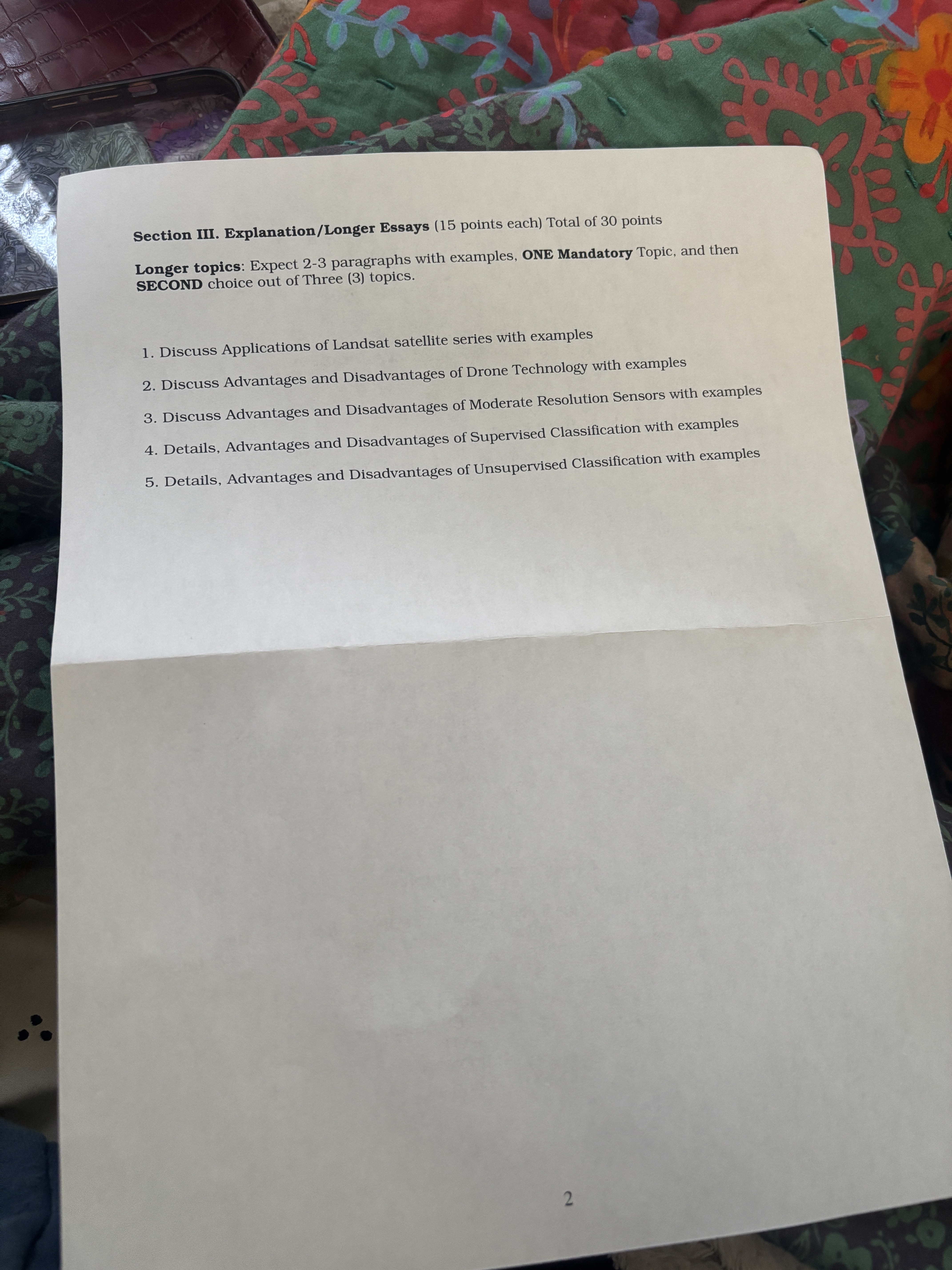
Section III — Explanation / Longer Essays
2 × 15 points = 30 points. Expect 2–3 paragraphs with examples.
Structure: One topic is mandatory; for the second, choose one of three.
1. Applications of the Landsat satellite series
Essay — Applications of the Landsat series.
- Continuity (since 1972) enables decadal change detection unmatched by any other system.
- Land-cover & land-use change. Deforestation (Amazon, Southeast Asia), urban growth, wetland loss.
- Agriculture. Crop-type mapping, yield forecasting via NDVI time series, irrigation monitoring.
- Water. Reservoir extent, glacier retreat, algal blooms (using thermal + VSWIR).
- Disaster response. Wildfire burn-scar mapping, flood extent, volcanic activity.
- Climate. Long-term surface-temperature records, snow-cover trends.
- Free & open data policy (since 2008) — the single biggest multiplier of Landsat’s impact.
2. Advantages and disadvantages of drone technology
Essay — Advantages and disadvantages of drone (UAS/UAV) technology.
Advantages
- Cm-level spatial resolution — far beyond any satellite.
- On-demand scheduling — fly when you need to, under clouds.
- Low cost per flight vs. piloted aircraft or tasking a satellite.
- Flexible payload — RGB, multispectral, thermal, LiDAR, hyperspectral.
- Ideal for small AOIs — field-scale agriculture, construction, infrastructure, wildlife.
Disadvantages
- Regulatory burden — US FAA Part 107 certification; altitude/line-of-sight limits; no-fly zones.
- Weather-limited — wind, rain, cold batteries.
- Small footprint — many flights and much stitching needed for regional coverage.
- Battery endurance — typically 20–40 min per flight.
- Data management — gigapixel orthomosaics strain storage and processing.
- Privacy & safety — public and airspace concerns.
3. Advantages and disadvantages of moderate-resolution sensors
Essay — Advantages and disadvantages of moderate-resolution sensors (10 – 250 m).
Examples: Landsat OLI (30 m), Sentinel-2 MSI (10 – 60 m), MODIS (250 – 1000 m).
Advantages
- Large swath (Landsat ~185 km, Sentinel-2 290 km) — regional/global coverage.
- Frequent revisit combined across constellations (Landsat + Sentinel-2 ≈ every 2–3 days).
- Long archives (Landsat → 1972) for time-series and change detection.
- Free data (USGS, ESA Copernicus).
- Multispectral breadth — enough bands for NDVI, EVI, NBR, water indices.
Disadvantages
- Can’t resolve individual objects — buildings, small fields, trees.
- Mixed pixels at class boundaries hurt classification accuracy.
- Cloud contamination — 16-day repeat means many scenes are unusable.
- Thermal resolution is coarser still (Landsat TIRS 100 m → resampled to 30 m).
4. Supervised classification — details, advantages, disadvantages
Essay — Supervised classification: details, advantages, disadvantages.
How it works
- Define training sites (AOIs) for each known class.
- Compute class signatures (mean + covariance per band).
- Apply a decision rule — Minimum Distance, Mahalanobis, Maximum Likelihood, Parallelepiped — to every pixel.
- Evaluate with an accuracy assessment (confusion matrix, kappa).
Advantages
- You control the class scheme — matches the analyst’s question.
- Higher accuracy than unsupervised when training data is good.
- Works well when classes are spectrally distinct and well-sampled.
Disadvantages
- Labor-intensive — collecting good ground truth takes time.
- Bias risk — classes not represented in training won’t be predicted.
- Assumes training statistics generalize across the scene (fails on mixed pixels or rare classes).
- Maximum Likelihood requires multivariate-normal class distributions.
5. Unsupervised classification — details, advantages, disadvantages
Essay — Unsupervised classification: details, advantages, disadvantages.
How it works
- Choose the number of clusters (e.g., ISODATA or K-means).
- Algorithm iterates: assign pixels to nearest cluster centroid → recompute centroids → repeat until convergence.
- Analyst labels each cluster post-hoc by comparing to reference data.
Advantages
- No training data required — fast first pass for unfamiliar scenes.
- Reveals natural spectral groupings the analyst might not have predicted.
- Useful as a preprocessing step for supervised classification or for stratifying sampling.
Disadvantages
- Clusters don’t always map cleanly to meaningful land-cover classes — one class may split across clusters, or a single cluster may contain several classes.
- Sensitive to K and initial seeds; different runs can give different results.
- Post-classification labeling and merging (often via Recode) is still required.
About the proctoring setup
Respondus LockDown Browser is a custom browser that locks down the testing environment inside Blackboard — while the exam is open you cannot open other applications, switch tabs, copy/paste outside the exam, print, or screenshot.
Respondus Monitor uses your webcam and microphone to record a short environment check and the exam session. It flags unusual activity (extra voices, leaving the frame, phones in view, etc.) for the instructor to review after the fact.
Practical tip: install and run a practice quiz before exam day, make sure the webcam works, use a quiet well-lit spot, have only the permitted materials in view, and keep your ID ready for the environment scan.